
Vestvågøy
- 48
Rystad - Burials
|
Site/Artefact Type Site
Number NGO Grid
Reference Map (
1:50000) List of Sites
and Artefacts Interactive
Map |
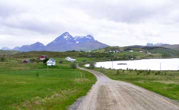 Overview of the Rystad-area (Photo: Lofotr, The Vikingmuseum) |
Description
Registrations in 1978 supply us with
following information.
3 Burial Cairns, situated at farm nr. 94/ 4, 10 159 m north west from the farm houses.
Furthest to the North:
1. Round Cairn: 4,5 m in dm, 0,2-0,3 m high
4 m south south east of 1:
2. Round Cairn, 8-9 m in dm, 0,7 m high
Nearly 35 m south south west of 2:
3. Round Cairn, 4,5 m in dm, 0,2 m high
Excavation Details
Not Available
Access/Ownership
Private property
References
- National Registrations and supplement registrations, Topographical Archive, Museum of Tromsø
Check out the following sections of the website for related information:
Vestvågøy Sites and Artefacts
Mayo - Vestvågøy - Mid-Argyll
Travels in Time | Overview | Themes |
Timelines | 700BC to 0 | 0 to 800AD | 800AD to 1100AD |
Landscape | Mayo | Vestvågøy | Mid-Argyll | Archaeology |
Other Media | Education | Exhibition | Publication |
Information | Bibliography | Project | Links | Contact |
 This
project has been supported by the EU as part of the Culture
2000 programme.
This
project has been supported by the EU as part of the Culture
2000 programme.