
Vestvågøy
- 42
Bøstad House Sites and Pollen
Analysis
|
Site/Artefact Type Site
Number NGO Grid
Reference Map (
1:50000) List of Sites
and Artefacts Interactive
Map |
|
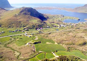
Description
Registrations in 1970 supply us with the
following information:
House site 17x10 m, situated close Borge River at farm nr. 92/1 about 200 m west of the houses at farm nr. 92/2, 14. reference: R3 3155 H12. Small scale excavation is done at this site.
House site 16x7, situated at farm nr. 92/3, 14, 200 m W of house site R1 3155 H12 and 400 m W of the farm houses. ?Kreference: R1 3155H10.
150 m north north east of the house sites, a burial mound is situated, 4-5 m in dm, 60 m east of the house site, stones build up a spring: 1,1 x 0,9 m (inner measures)
Excavation Details
Excavation of house site R3 3155 H12 was
carried out by Olav S. Johansen in 1973. The
structures indicates a date to the Merovingian
Period or Viking Age, but dating from earlier
cultural layers and hearth covers the period
between BC 200 - AD 1000.
Finds from the excavationsmall iron sickle, different shreds of clay and a bead of rock crystal (museum number TS7734).
Pollen analysis from 1976 indicates cultivation of barley back to BC 2000. The farm has probably been deserted after the Black Death in the middle of the 12th century.
Access/Ownership
Private property
References
- Olav Sverre Johansen 1979: De nordnorske tunanleggene fra jernalderen, i Viking
- National Registrations: Topographical archive, Museum of Tromsø
Vestvågøy Sites and Artefacts
Mayo - Vestvågøy - Mid-Argyll
Travels in Time | Overview | Themes |
Timelines | 700BC to 0 | 0 to 800AD | 800AD to 1100AD |
Landscape | Mayo | Vestvågøy | Mid-Argyll | Archaeology |
Other Media | Education | Exhibition | Publication |
Information | Bibliography | Project | Links | Contact |
 This
project has been supported by the EU as part of the Culture
2000 programme.
This
project has been supported by the EU as part of the Culture
2000 programme.