
Mid-Argyll -
16
Dunadd Fort
|
Site/Artefact Type Site
Number National Grid
Reference Map (
1:25000) List of Sites
and Artefacts Interactive
Map |
|
Excavation Details
Excavations here in 1904-5, 1925 and
1980-1 showed Dunadd's central importance in
6th-8th centuries AD with its domineering
architecture and rich goods imported from Britain
and the Continent. There is evidence for
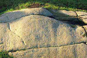
metalworking and for ecclesiastical influence. Rock
carvings suggest it may have been where early kings
were inaugurated.
 Description
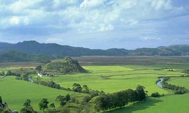
Rising out of the Great Moss, Dunadd,
worn down by successive ice-ages, stands sentinel
as the River Add snakes around its feet. Since
prehistory, people have been drawn by its powerful
setting and have left their marks: the footprints
of the Dalriadic Kings, the carved wild boar of the
Picts, enigmatic messages in the early Celtic
script - subtle evidence of comings and goings,
feuds and unions. It was here the Scottish nation
was born.
Dunadd rises out of the flat flood plain, the undrained portion of which is still raised bog (Moine Mhor) which can be seen by the dark vegetation in the distance. The River Add can be seen meandering towards the sea at Crinan. The island of Jura and Scarba can be seen on the horizon.
Access/Ownership
The site is managed by Historic Scotland with free
access from dedicated car park close by.
References
- RCAHMS Argyll vol. 6 no. 248
- RCAHMS Argyll vol. 7 no 281
- PSAS 38 (1903-4) p205-51
- PSAS 39 (1904-5) p292-322
- PSAS 64 (1929-30) p111-127
- PSAS 95 (1960-1) p46 no. 315-6
- Allan Lane & Ewan Campbell
Check out the following sections of the website for related information
Mid-Argyll Sites and Artefacts
Mayo - Vestvågøy - Mid-Argyll
Travels in Time | Overview | Themes |
Timelines | 700BC to 0 | 0 to 800AD | 800AD to 1100AD |
Landscape | Mayo | Vestvågøy | Mid-Argyll | Archaeology |
Other Media | Education | Exhibition | Publication |
Information | Bibliography | Project | Links | Contact |
 This
project has been supported by the EU as part of the Culture
2000 programme.
This
project has been supported by the EU as part of the Culture
2000 programme.