
Mid-Argyll -
47
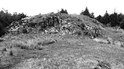
Dun Mor, Dunchraigaig
|
Site/Artefact Type Site
Number National Grid
Reference Map (
1:50000) List of Sites
and Artefacts Interactive
Map |
 |
Excavation Details
Not Excavated
Description
The dun is situated on the summit of a
ridge. It measures about 20m in diameter but its
origingal plan has been largely obscured by the
building of paths and ramps in the 19th c. The best
part of the wall is the outer face which stands
0.65m high (five courses) close to the entrance.
The entrance has a well-defined entrance passage
3.5m long and 1.5m wide. Traces of an outer wall
lie on the terraces below, the best preserved part
of the outer wall standing to 0.5m high (two
courses) and the N side-wall of the entrance
passage also remains.
Access/Ownership
This site is on private land and permission should
be sought.
References
- Campbell and Sandeman, 51, no.344
Mid-Argyll Sites and Artefacts
Mayo - Vestvågøy - Mid-Argyll
Travels in Time | Overview | Themes |
Timelines | 700BC to 0 | 0 to 800AD | 800AD to 1100AD |
Landscape | Mayo | Vestvågøy | Mid-Argyll | Archaeology |
Other Media | Education | Exhibition | Publication |
Information | Bibliography | Project | Links | Contact |
 This
project has been supported by the EU as part of the Culture
2000 programme.
This
project has been supported by the EU as part of the Culture
2000 programme.