
Mid-Argyll -
56
Anaskeog
|
Site/Artefact Type Site
Number National Grid
Reference Map (
1:50000) List of Sites
and Artefacts Interactive
Map |
 |
Excavation Details
Not Excavated
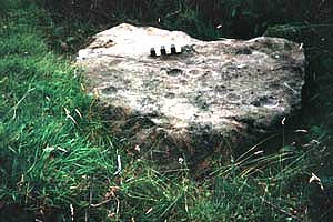
Description
This cup-marked boulder is situated in a
forestry plantation about 450m E of Killinochonoch.
It bears fourteen circular and two oval
cupmarks.
Access/Ownership
References
- RCAHMS Argyll vol. 6 no.115
Mid-Argyll Sites and Artefacts
Mayo - Vestvågøy - Mid-Argyll
Travels in Time | Overview | Themes |
Timelines | 700BC to 0 | 0 to 800AD | 800AD to 1100AD |
Landscape | Mayo | Vestvågøy | Mid-Argyll | Archaeology |
Other Media | Education | Exhibition | Publication |
Information | Bibliography | Project | Links | Contact |
 This
project has been supported by the EU as part of the Culture
2000 programme.
This
project has been supported by the EU as part of the Culture
2000 programme.