
Mid-Argyll -
53
Dunadd
|
Site/Artefact Type Site
Number National Grid
Reference Map (
1:50000) List of Sites
and Artefacts Interactive
Map |
 |
Excavation Details
Not excavated
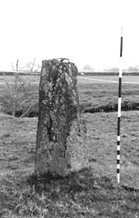
Description
This formerly and upright stone now
fallen, measuring 4.3m in length.
Access/Ownership
This site is on private land and permission should
be sought.
References
- Name Book, no.16, p.22
- PSAS, 38 (1903-4), 131
- Campbell & Sandeman, 26, no.175
Mid-Argyll Sites and Artefacts
Mayo - Vestvågøy - Mid-Argyll
Travels in Time | Overview | Themes |
Timelines | 700BC to 0 | 0 to 800AD | 800AD to 1100AD |
Landscape | Mayo | Vestvågøy | Mid-Argyll | Archaeology |
Other Media | Education | Exhibition | Publication |
Information | Bibliography | Project | Links | Contact |
 This
project has been supported by the EU as part of the Culture
2000 programme.
This
project has been supported by the EU as part of the Culture
2000 programme.