
Mid-Argyll -
26
Nether Largie
|
Site/Artefact Type Site
Number National Grid
Reference Map (
1:25000) List of Sites
and Artefacts Interactive
Map |
|
Excavation Details
 Excavated
in 1973.
Excavated
in 1973.
Description
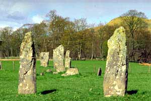
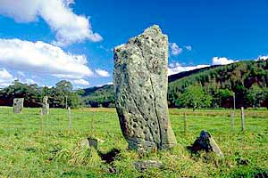
Complex setting of standing stones which
lies 250m SE of Temple Wood stone circle. Two pairs
of standing stones lie approximately 64 metres
apart with a small group of four stones and another
of five stones between them. Recent geophysical
survey suggests other features and earthworks may
have been associated with the settings.
The tallest of the southernmost pair of stones is 2.8m high and has 3 cupmarks on one face, the tallest of the group of five stones is also 2.8m high and has 40 cupmarks on one face, while the tallest of the northernmost pair of stones is again 2.8m high and the smaller of the pair has three cupmarks.
Another stone lies 100m away from the northern end and the stump of another (discovered in 1973) lies 300m away from the southern end.
Archeoastronomers believe that this complex site could track the movements of the sun and moon and therefore be used to predict such events as eclipses.
Access/Ownership
This site, although located on private land is due
to have a formal public access opened in the spring
of 1998 via a new car park 1km south of Kilmartin
at the Crinan turn off.
References
- PSAS, 6 (1864-6), 338
- Campbell & Sandeman, 21, no.146
- Campbell & Sandeman, 34, no.242
- Morris, 110, ARG 68
- DES (1982), 22
- Glasgow Herald, 1 September 1973
- DES (1973), 13
- Kist, 8 (1974), 6
- Hawkins, "Mindsteps to the Cosmos" (1983), 100-2
Mid-Argyll Sites and Artefacts
Mayo - Vestvågøy - Mid-Argyll
Travels in Time | Overview | Themes |
Timelines | 700BC to 0 | 0 to 800AD | 800AD to 1100AD |
Landscape | Mayo | Vestvågøy | Mid-Argyll | Archaeology |
Other Media | Education | Exhibition | Publication |
Information | Bibliography | Project | Links | Contact |
 This
project has been supported by the EU as part of the Culture
2000 programme.
This
project has been supported by the EU as part of the Culture
2000 programme.