
Mid-Argyll -
27
Ballymeanoch - Standing Stones
|
Site/Artefact Type Site
Number National Grid
Reference Map (
1:25000) List of Sites
and Artefacts Interactive
Map |
|
Excavation Details
 The
stump of a fallen stone was excavated and removed
in 1977.
The
stump of a fallen stone was excavated and removed
in 1977.
Description
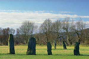
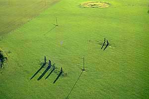
This setting now comprises six stones
arranged in two roughly parallel lines aligned
NW-SE. Excavation revealed cremation deposits under
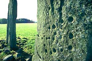
the stump of a fallen seventh stone which stood 18m
WNW of the main setting and was decorated with
cup-and-ring marks and one complete perforation.
Nearby are several other prehistoric monuments.
This view from the SW shows the two parallel rows of standing stones, these are the tallest erect stones in the area with some more than 4m high. The woodland behind contains a number of cists, known about before the area was planted with conifers. Since the felling of the conifers in 1995 only 1 has been rediscovered.
Access/Ownership
All the Ballymeanoch monuments are managed by
Historic Scotland and accessible via pathways
leading from the dedicated car park at
Duncraigaig.
References
- Campbell & Sandeman, 24, no.158
- PSAS, 109 (1977-8), 104-11
- Morris, 55-6, ARG 16
- PSAS, 16 (1881-2), 114-17
Mid-Argyll Sites and Artefacts
Mayo - Vestvågøy - Mid-Argyll
Travels in Time | Overview | Themes |
Timelines | 700BC to 0 | 0 to 800AD | 800AD to 1100AD |
Landscape | Mayo | Vestvågøy | Mid-Argyll | Archaeology |
Other Media | Education | Exhibition | Publication |
Information | Bibliography | Project | Links | Contact |
 This
project has been supported by the EU as part of the Culture
2000 programme.
This
project has been supported by the EU as part of the Culture
2000 programme.