
Mid-Argyll -
37
Carnassarie - Round Cairn
|
Site/Artefact Type Site
Number National Grid
Reference Map (
1:25000) List of Sites
and Artefacts Interactive
Map |
 |
Excavation Details
The cairn was excavated in 1930.
Description
This is one of a group of three cairns.
This cairn is about 25m in diameter and now
measures only 1.3m in height. The largest of the
group, also known as Carn Ban, is 20m in diameter
and over 3m high and commands wide views. Some
original kerbstones remain round its perimeter, and
a modern cairn has been built on its top. The third
cairn is what may be a poorly preserved
burial-cairn, 21m by 19m, with a possible chambered
cairn in the centre. From this large commanding
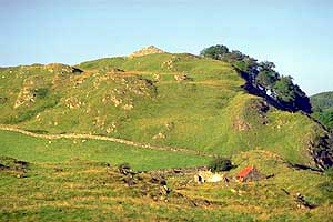
cairn it is possible to see all the way down the
Kilmartin Valley. This view is taken looking N with
the abandoned village of Old Carnassarie in the
foreground. The easiest access route is to follow
the track leading beneath Carnassarie Castle from
the signposted car park.
Access/Ownership
Beyond the Castle it is private ground and
permission should be sought.
References
- Campbell & Sandeman, 9, n.44
- Campbell & Sandeman, 12, no.70
- PSAS, 65 (1930-1), 375-8
- PSAS 95 (1960-1) p 9 no. 44
- DES (1976), 15
- RCAHMS Argyll vol. 6 no. 35 (1)
Mid-Argyll Sites and Artefacts
Mayo - Vestvågøy - Mid-Argyll
Travels in Time | Overview | Themes |
Timelines | 700BC to 0 | 0 to 800AD | 800AD to 1100AD |
Landscape | Mayo | Vestvågøy | Mid-Argyll | Archaeology |
Other Media | Education | Exhibition | Publication |
Information | Bibliography | Project | Links | Contact |
 This
project has been supported by the EU as part of the Culture
2000 programme.
This
project has been supported by the EU as part of the Culture
2000 programme.