
Mid-Argyll -
29
Ballymeanoch
|
Site/Artefact Type Site
Number National Grid
Reference Map (
1:25000) List of Sites
and Artefacts Interactive
Map |
 |
Excavation Details
Not excavated
Description
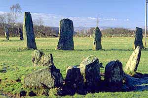
This view from the SW shows the two
parallel rows of standing stones from within the
adjacent kerb cairn. One of the fallen outlying
stones that has been removed from its original
position is now to be found in several pieces in
the ditch beside this kerb cairn. It was a rather
unusual stone as it was perforated with a large
hole said to have been used in betrothal ceremonies
up to recent times. The kerb cairn probably dates
to 1,400 BC - 1,200BC.
Access/Ownership
All the Ballymeanoch monuments are managed by
Historic Scotland and accessible via pathways
leading from the dedicated car park at
Duncraigaig.
References
- RCAHMS Argyll vol. 6 no. 199
- PSAS 16 (1881-2) 114-17
- PSAS 95 (1960-1) p24 no. 158
- PSAS 109 (1977-8) p104-11
- Discovery and Excavation in Scotland 1993 p75
- RCAHMS Argyll vol. 6 no. 31
- PSAS 63 (1928-9) p 189
- PSAS 95 (1961-2) p11 no. 64
Mid-Argyll Sites and Artefacts
Mayo - Vestvågøy - Mid-Argyll
Travels in Time | Overview | Themes |
Timelines | 700BC to 0 | 0 to 800AD | 800AD to 1100AD |
Landscape | Mayo | Vestvågøy | Mid-Argyll | Archaeology |
Other Media | Education | Exhibition | Publication |
Information | Bibliography | Project | Links | Contact |
 This
project has been supported by the EU as part of the Culture
2000 programme.
This
project has been supported by the EU as part of the Culture
2000 programme.