
Mid-Argyll -
52
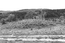
Ballymeanoch
|
Site/Artefact Type Site
Number National Grid
Reference Map (
1:50000) List of Sites
and Artefacts Interactive
Map |
 |
Excavation Details
Not Excavated
Description
The dun is on a site which is relatively
level on all sides except to the SE where it falls
away steeply. It has a diameter of 10m . The inner
face of the wall can be traced for nearly all its
circuit and measures 1m (three courses) at its
highest. Less of the outer face is visible, the
best preserved is 0.95m high (six courses) and in
the S it is set 2m below the level of the interior
where the wall is 4.8m thick. The entrance is 1m
wide at the inner end.
Access/Ownership
This site is on private land and permission should
be sought
References
- Campbell and Sandeman, 42-3, no.298
Mid-Argyll Sites and Artefacts
Mayo - Vestvågøy - Mid-Argyll
Travels in Time | Overview | Themes |
Timelines | 700BC to 0 | 0 to 800AD | 800AD to 1100AD |
Landscape | Mayo | Vestvågøy | Mid-Argyll | Archaeology |
Other Media | Education | Exhibition | Publication |
Information | Bibliography | Project | Links | Contact |
 This
project has been supported by the EU as part of the Culture
2000 programme.
This
project has been supported by the EU as part of the Culture
2000 programme.