
Mid-Argyll -
30
Dunchragaig
|
Site/Artefact Type Site
Number National Grid
Reference Map (
1:25000) List of Sites
and Artefacts Interactive
Map |
|
Excavation Details
The site was excavated by Mapleton, and
then in 1864, by Greenwell. This excavation
revealed 3 cists. This one was dug into the old
ground surface with sides formed of drystone
walling. The burnt and unburnt bones of 8-10 people
were found, roughly separated by stone
fragments.
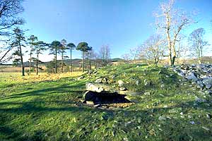
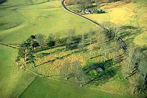
Description
The cairn is constructed of water-worn
boulders and measures about 30m in diameter. It
contains three cists, two of which are visible (as
a result of stone robbing). The first is
constructed of five slabs and the second is
hollowed into the ground and has roughly built
drystone walls. Both have covering slabs.The
largest is clearly visible on the SE side of the
cairn, missing one of its sides its large capstone
is still in position.
Finds include two finely decorated Food Vessels and a stone axe.
Now surrounded by the exotic trees planted in the mid-19th century as part of the planned parkland landscape that appropriated a number of local monuments as secluded "picnic spots".
Access/Ownership
The site is owned by Historic Scotland and is open
to the public. The site has parking.
References
- Campbell & Sandeman, 15, no.95
- RCAHMS Argyll vol 6 no. 48
- PSAS 6 (1864-6) p347-8
- PSAS 95 (1961-2) p15 no. 95
- Journal of the Ethnological Society of London, 2 (1869-70), 148, 150
Mid-Argyll Sites and Artefacts
Mayo - Vestvågøy - Mid-Argyll
Travels in Time | Overview | Themes |
Timelines | 700BC to 0 | 0 to 800AD | 800AD to 1100AD |
Landscape | Mayo | Vestvågøy | Mid-Argyll | Archaeology |
Other Media | Education | Exhibition | Publication |
Information | Bibliography | Project | Links | Contact |
 This
project has been supported by the EU as part of the Culture
2000 programme.
This
project has been supported by the EU as part of the Culture
2000 programme.