
Mid-Argyll -
44
Poltalloch
|
Site/Artefact Type Site
Number National Grid
Reference Map (
1:50000) List of Sites
and Artefacts Interactive
Map |
 |
Excavation Details
Opened in 1928, no finds
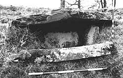
Description
A single cist visible on the edge of the
terrace about 0.5m below ground level. It measures
1.34m by 0.6m and is 0.64m deep.
Access/Ownership
This site is on private land and permission should
be sought
References
- PSAS, 63 (1928-9), 189, 155-66; 65 (1930-1), 279
- Campbell and Sandeman, 21, no.147; 19, no.129 & no.130;
- GAJ, 8 (1981), 19-28
- DES, (1961), 11
Mid-Argyll Sites and Artefacts
Mayo - Vestvågøy - Mid-Argyll
Travels in Time | Overview | Themes |
Timelines | 700BC to 0 | 0 to 800AD | 800AD to 1100AD |
Landscape | Mayo | Vestvågøy | Mid-Argyll | Archaeology |
Other Media | Education | Exhibition | Publication |
Information | Bibliography | Project | Links | Contact |
 This
project has been supported by the EU as part of the Culture
2000 programme.
This
project has been supported by the EU as part of the Culture
2000 programme.