
Mid-Argyll -
2
Druim an Dúin
|
Site/Artefact Type Site
Number National Grid
Reference Map (
1:25000) List of Sites
and Artefacts Interactive
Map |
 |
Excavation Details
The dun was excavated by the Society of
Antiquaries of Scotland in 1904-5 but the work
appears to have consisted of little more than stone
clearance.
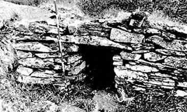
Description
This well preserved dun occupies a
commanding position at the N end of a ridge which
overlooks a sharp bend in the public road (B8025)
that runs from the head of Caol Scotnish to
Bellanoch. The site is easily approached from the
SW along the spine of the ridge, but on the NE and
SE it is flanked by long steep slopes and on the NW
by a precipitous cliff some 30m in height. A
portion of rotary quern found here suggests that it
was used after 1st century BC, when this piece of
equipment became popular.
Access/Ownership
Not Available
References
- RCAHMS Argyll vol 6 no.293
Check out the following sections of the website for related information
Mid-Argyll Sites and Artefacts
Mayo - Vestvågøy - Mid-Argyll
Travels in Time | Overview | Themes |
Timelines | 700BC to 0 | 0 to 800AD | 800AD to 1100AD |
Landscape | Mayo | Vestvågøy | Mid-Argyll | Archaeology |
Other Media | Education | Exhibition | Publication |
Information | Bibliography | Project | Links | Contact |
 This
project has been supported by the EU as part of the Culture
2000 programme.
This
project has been supported by the EU as part of the Culture
2000 programme.