
Mid-Argyll -
3
Duntroon
|
Site/Artefact Type Site
Number National Grid
Reference Map (
1:25000) List of Sites
and Artefacts Interactive
Map |
 |
Excavation Details
The site was excavated in 1904 by the
Society of Antiquaries.
Finds included :
- thirty-six saddle querns, five hammer stones, four whetstones or polishers
- three flint scrapers, a piece of jet or lignite, six pebbles with indications of wear, various flakes and cores.
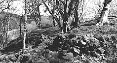
Description
A vitrified fort situated on the wooded
summit of a ridge which is protected on the NW by a
steep cliff, and on the NE by a narrow gully. On
the SW and SE where there is no natural protection
a series of outworks have been built. The main area
enclosed measures about 45m by 27m and the wall is
up to 2.5m thick. No remains of the inner face are
visible but the outer face stands to height of 1.3m
(three courses) in the W. The wall was constructed
with strengthening timber beams and, due to fire,
these have vitrified - fusing with the stone of the
wall. The position of the entrance is not clear.
There are the rubble remains of an outer wall once
2m thick, on a lower terrace. Two further outer
walls can be traced on the SW but these have been
largely desroyed by stone-robbing.
Access/Ownership
This site is on private land and permission should
be sought.
References
- PSAS, 39 (1904-5), 270-85
- Campbell and Sandeman, 55, no.364
Check out the following sections of the website for related information
Mid-Argyll Sites and Artefacts
Mayo - Vestvågøy - Mid-Argyll
Travels in Time | Overview | Themes |
Timelines | 700BC to 0 | 0 to 800AD | 800AD to 1100AD |
Landscape | Mayo | Vestvågøy | Mid-Argyll | Archaeology |
Other Media | Education | Exhibition | Publication |
Information | Bibliography | Project | Links | Contact |
 This
project has been supported by the EU as part of the Culture
2000 programme.
This
project has been supported by the EU as part of the Culture
2000 programme.