
Mid-Argyll -
25
Ri Cruin
|
Site/Artefact Type Site
Number National Grid
Reference Map (
1:25000) List of Sites
and Artefacts Interactive
Map |
|
Excavation Details
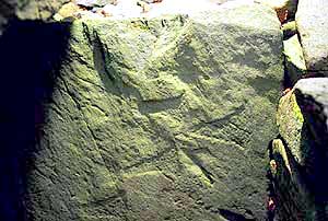
Excavated by Mapleton in 1870, Craw in
1929 and Childe in 1936, the cairn is now largely a
reconstruction. Three cists were found, two with
grooved side-slabs. A third contained a slab with a
vertical groove and short strokes at right angles.
The cist's end-slab is decorated with carved
axes.
Description
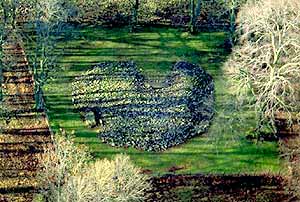
The most southerly cairn of the linear
cemetery. Now surrounded by the exotic trees
planted in the mid-19th century as part of the
planned parkland landscape that appropriated a
number of local monuments as secluded "picnic
spots". The cairn is largely reconstructed and
contains three cists. One cist has collapsed and
only the side slabs remain. Another lies just
inside the kerb of stones, set into a pit. It is
partly covered by a large capstone and has an end
slab decorated with axes. It appears that a now
removed lime kiln was built into the fabric of the
cairn in the 18th century.
Access/Ownership
Maintained by Historic Scotland, foot access via
path running along in front of Ri Cruin
farmhouse.
References
- RCAHMS Argyll vol 6 no. 76
- PSAS 8 (1868-70) p378-81
- PSAS 64 (1929-30) p131-4
- PSAS 95 (1961-2) p18 no. 119, p38 no. 270
- Morris The Prehistoric Rock Art of Argyll 1977 p117, ARG 74
- Campbell & Sandeman, 18, no.119; 38, no.270
Mid-Argyll Sites and Artefacts
Mayo - Vestvågøy - Mid-Argyll
Travels in Time | Overview | Themes |
Timelines | 700BC to 0 | 0 to 800AD | 800AD to 1100AD |
Landscape | Mayo | Vestvågøy | Mid-Argyll | Archaeology |
Other Media | Education | Exhibition | Publication |
Information | Bibliography | Project | Links | Contact |
 This
project has been supported by the EU as part of the Culture
2000 programme.
This
project has been supported by the EU as part of the Culture
2000 programme.