
Mid-Argyll -
36
Creag a' Mhadaidh
|
Site/Artefact Type Site
Number National Grid
Reference Map (
1:25000) List of Sites
and Artefacts Interactive
Map |
 |
Excavation Details
Not excavated
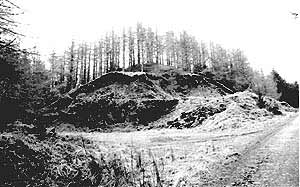
Description
This dun is situated on a knoll in a
forestry plantation, immediately N of the track
from Kilmartin to Ormaig and E of a disused quarry.
Stone robbing has reduced the wall to little more
than a band of core material about 2.5m thick,
which encloses an area measuring 11m by 9.5m; a
short stretch of the outer face remains in position
on the SW. The entrance lay either on the NE or E,
where the rubble is reduced in height. A terrace on
the NE may have been enclosed by an outwork. In the
interior, an arc of recent walling abuts the dun
wall on the SW.
References
- RCAHMS Argyll vol 6 no. 290
Mid-Argyll Sites and Artefacts
Mayo - Vestvågøy - Mid-Argyll
Travels in Time | Overview | Themes |
Timelines | 700BC to 0 | 0 to 800AD | 800AD to 1100AD |
Landscape | Mayo | Vestvågøy | Mid-Argyll | Archaeology |
Other Media | Education | Exhibition | Publication |
Information | Bibliography | Project | Links | Contact |
 This
project has been supported by the EU as part of the Culture
2000 programme.
This
project has been supported by the EU as part of the Culture
2000 programme.