
Mayo -
11
Kiladangan
|
Site/Artefact Type Site
Number National Grid
Reference Map (
1:50000) List of Sites
and Artefacts Interactive
Map |
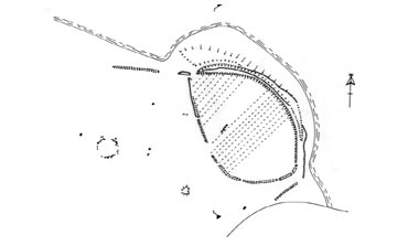 Diagram showing the main elements of the Kiladangan Archaeological Complex (after Morahan, 2001)
|

Description
Kiladangan, meaning the wood of the
stronghold or fortress is a complex of standing
stone monuments including a row of standing stones,
a pair of standing stones, a stone circle and three
orthostats. The large oval shaped- bivallate
enclosure which will one day perish to the
advancing sea, guards a stone row consisting of
four stones aligned NNE - SSW (Morahan, 2001). A
remarkable event takes place here on the winter
solstice (21st December) when the sun sets in a
natural recess 2km directly SSW in the eastern
shoulder of Croagh Patrick (Corlett, 2001).
South-west of the stone row is a burnt mound,
(fulacht fiadh).
Excavation Details
Not Available
Access/Ownership
Clew Bay Heritage Trail
References
- Corlett, C. 2001 Antiquities of West Mayo, Wordwell, Wicklow, p.113
- Corlett, C. 1998 The Prehistoric Ritual Landscape of Croagh Patrick, Co. Mayo, Journal of Irish Archaeology, vol. 9, pp 9-26
- Morahan, L. 2001 Croagh Patrick, Co. Mayo archaeology, landscape and people, Croagh Patrick Archaeological Committee, Mayo, p.109,p.154
Check out the following sections of the website for related information:
Mayo Sites and Artefacts
|
1. Mayo Abbey |
18. Carrowmore |
31. Glaspatrick
Rath-1 |
Mayo - Vestvågøy - Mid-Argyll
Travels in Time | Overview | Themes |
Timelines | 700BC to 0 | 0 to 800AD | 800AD to 1100AD |
Landscape | Mayo | Vestvågøy | Mid-Argyll | Archaeology |
Other Media | Education | Exhibition | Publication |
Information | Bibliography | Project | Links | Contact |
 This
project has been supported by the EU as part of the Culture
2000 programme.
This
project has been supported by the EU as part of the Culture
2000 programme.